It was still day 3 when we crossed the border from Texas to New Mexico. Unlike my trip with Peter to Utah’s Mighty 5 a few weeks prior where we were chasing the sunrise, my dad and I found ourselves constantly chasing the sunset. We drove Route 66 from June 17-22 when the sun was setting late in the evening but we still failed to make it to our hotels before the sunset.
Our first stop in New Mexico was in a small town named Tucumcari (pronounced “too-koom-cah-ree”). Tucumcari is at an elevation of just over 4,000 ft / 1,220 m and it was hot! Very hot!
Tucumcari was founded in 1901 and acquired its name from nearby Tucumcari Mountain. The mountain signaled travelers of Route 66 (and later Interstate 40) that rest was nearby.
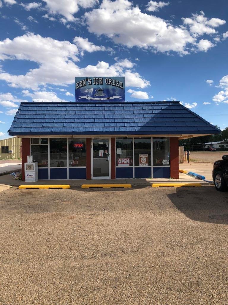
Route 66 (now Tucumcari Blvd) runs through Tucumcari. The city layout mimics the two miles of Route 66 that runs through it. It’s often said that Tucumcari is a city that is two blocks wide and two miles long. It was desolate with not much going on aside from a couple of historic Route 66 motels, Ken’s Diner, and the chrome Route 66 sculpture.
We chose to get a burger and fries at Ken’s Ice Cream which also dubs as a historic Route 66 diner. As luck would have it, Ken’s air conditioning was broken the day of our visit and it was a toss-up on whether it was cooler outside in the blazing sun or in the tiny diner with the grill flame broiling food a few feet from our table.
I am a person who eats a hamburger about twice a year so the stop at Ken’s was a big deal and I had high hopes and full knowledge that I would suffer from heartburn for the next 48 hours from our meal but it was Route 66 and was a must that we eat at a diner on Route 66.
We were the only people in the diner and we waited 45 minutes for our two burgers and shared an order of fries. I do not know why it took so long but if you are considering stopping at Ken’s for a “quick bite,” then be warned.
Our next stop after Ken’s was to the chrome Route 66 sculpture. We nearly passed the sculpture as we were driving west on Route 66. I imagined a HUGE eye-catching sculpture. It was not. It was a tiny forgotten-about sculpture in what looked like an old bowling alley’s parking lot. It was so underwhelming that I realized after we departed Tucumcari that I took a photo of the wrong side of the sculpture.
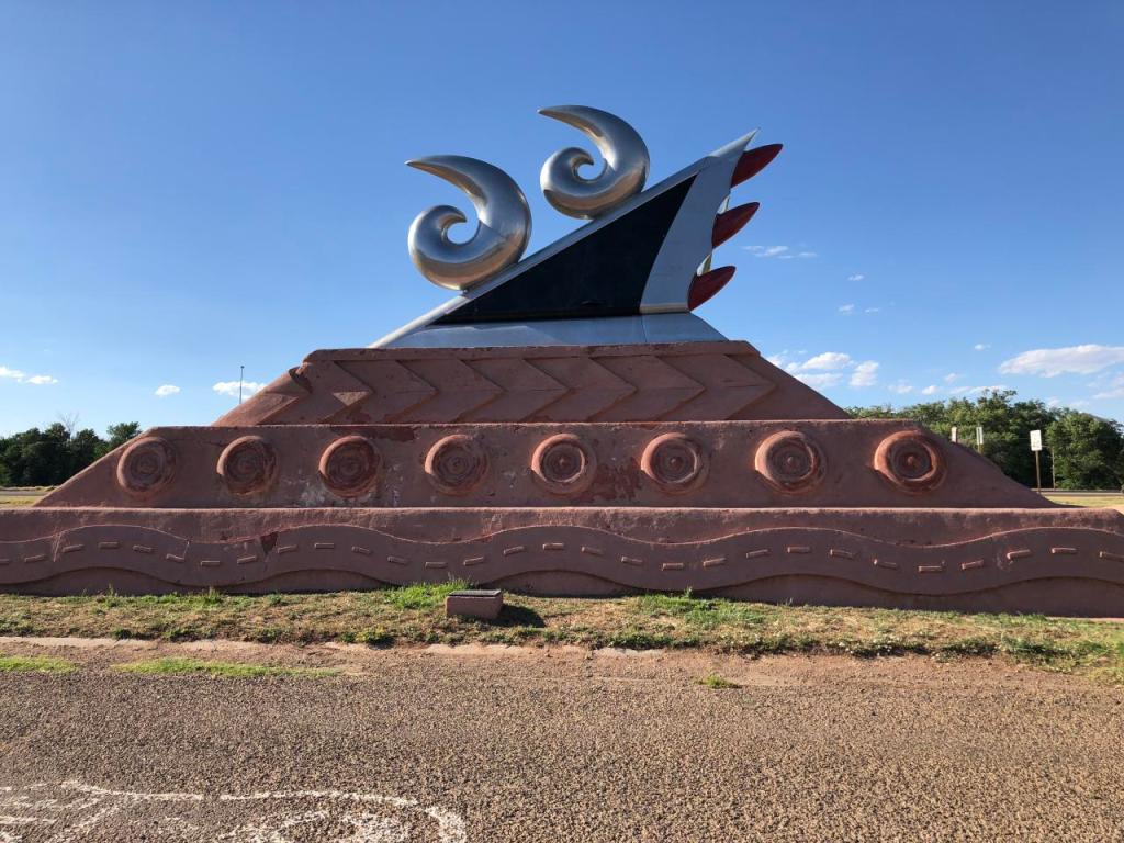
The two chrome “shrimps” on the top of the sculpture are actually 6’s and if I had taken the photo from the reverse (and correct) side of the sculpture, the word “Route” would have been seen in the black triangle with the chrome 66 above it. I was so focused on not getting the “bowling alley” (in reality, the Tucumcari Convention Center) in the photo that I chose to take the photo from this side of the sculpture without even realizing it was the incorrect side. It was also fucking hot outside!
Below is my rendition of what the other side looks like. It makes a lot more sense, doesn’t it?
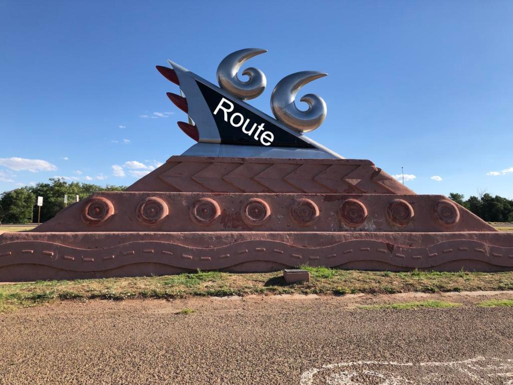
The sculpture was built in 1997 by Thomas Coffin. The red stone symbolizes the road and tires and the chrome upper part is a tailfin with 1950s taillights that actually illuminate at night!
This might have been the least visually appealing sculpture I have ever seen and I have spent too much time writing about Tucumcari. Onward to our next stop, The Santa Rosa Blue Hole, also known as the Blue Hole located in Santa Rosa.
New Mexico is basically all desert land. It is hot and dry and the landscape is red. The most surprising thing to me while driving through New Mexico was the number of trailer/mobile homes (in British English, caravans) sat in the middle of nowhere. Most were in very poor condition with sheet metal roofs and siding as a do-it-yourself solution to fix a decayed roof and siding. A collection of burnt-out cars usually surrounded the home. My dad’s theory is that the owner would buy a cheap car, drive it until it died in the yard and then repeat, repeat, repeat.
From afar, the living conditions looked deplorable and I wondered how the residents got on. Did they have air conditioning? Where did they go to buy food and supplies? Did they have jobs? How did they get water?
We saw thousands of isolated trailer homes throughout New Mexico and Arizona. It was a sad state of affairs.
Back to the topic at hand, the Blue Hole in Santa Rosa. Santa Rosa is located halfway between Albuquerque and Amarillo and is within a two-hour drive of 80 percent of New Mexicans! New Mexico is a very large state which tells me that most of the state is inhabited.
The Blue Hole is one of seven sister lakes connected underground by a system of water. Officially, it is a natural artesian well (a confined aquifer containing groundwater under positive pressure). The Blue Hole is always filled with water, even though it is located in the middle of the desert.
In the 1930s the Blue Hole was a fish hatchery and then it turned into a recreation area in the 1970s and then a bit later turned into the Blue Hole Dive and Conference Center. There were about 20 people chillin’ around the Blue Hole when we arrived. There are a few high rocks where brave people can jump into the Blue Hole.

The Blue Hole is 81 ft / 25 m deep and 60 ft 18 m wide (an Olympics-size swimming pool is 164 ft / 50 m long). The water is clear and pure. The colors reminded me of the Adriatic Sea off the coast of Croatia. Visibility is 100 ft due to the fact that the water in the hole renews itself every six hours. The water is a constant 62 degrees; perfect for taking a dip on a hot summer day like the day we visited.

Scuba divers drive up to 10 hours to dive into the Blue Hole and explore its hidden caves. On March 26, 2016, a diver became trapped in one of the passageways and drowned and in 1976, two divers also became trapped and drowned. Even given the risk, the Blue Hole is one of the most popular dive destinations in the US for SCUBA training.
The Blue Hole is worth a visit – bring your bathing suit (or swimming costume if you are a British English speaker) and take a dip!
It was after 7pm when we left the Blue Hole. We’d been on the road for a solid 12 hours at that point and had two hours of driving before reaching our final destination of the day, Albuquerque.
Our last stop of day 3 was at the Sandia Peak Tramway in Albuquerque. Ideally, it is best to ride the tramway when it is daylight or as the sun is setting but due to our late arrival and early departure the following day, the last uphill ride of the day at 9pm was all or nothing so we went for it.
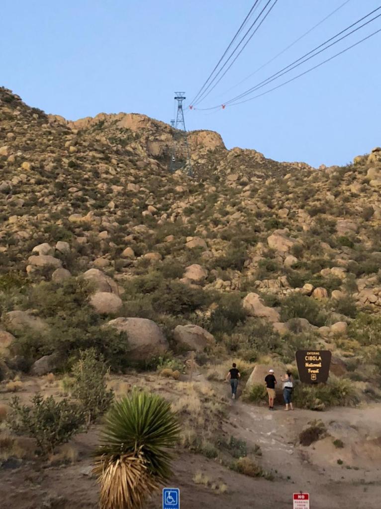
We had the tram to ourselves (a car can carry a maximum of 50 passengers) on the way up and were able to take photos of Albuquerque without having to elbow anyone in the face to get the hell out of my way. The ride is 2.7 mi / 4.35 km long from the base (6,559 ft / 1,999 m to the observation deck at Sandia Peak (10,378 ft / 3,163 m) and takes 15 minutes. It is the longest aerial tram in the US and has the third-longest span in the world.
Fun fact: Every day, a tramway worker rides on top of the tram car to the observation deck. They observe the cable on their ride up to ensure the cables are working properly.
The temperature at the observation deck was 30 degrees cooler than it was at the base and we were inappropriately dressed for the wind and lower temperatures in our shorts and t-shirts. Rookie mistake.
Fun fact: A tramway worker sleeps in a dorm-style room in the observation deck building every night. They are stationed at the observation deck to assist in emergencies on the mountain such as stranded hikers.
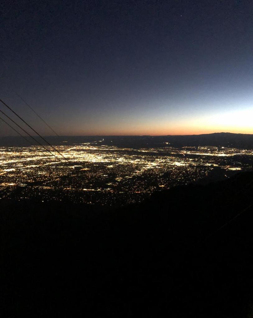
Even in the dark, I could see that there was an absence of tall buildings in Albuquerque. I learned that there are very strict codes on building heights in the city. The reason is to protect the views of the surrounding mountains and natural beauty.
Below is one of my favorite photos of our Route 66 trip. I took it on the ride up to the observation deck and did not realize that it was blurry until I reviewed my photos the following day.

Once back at the base, we drove to our hotel, arriving at 10:20pm and that was it for day 3.
| Beginning mileage day 3 | 11,857 |
| Ending mileage day 3 | 12,582 |
| Total miles driven day 3 | 725 |
We were in Albuquerque for 10 hours and most of that time was spent sleeping but I departed Albuquerque wanting to return. On our drive out of the city on day 4, we saw hot air balloons filling up and taking flight a short distance from the highway. The backdrop of the hot air balloons against the red mesas and the rising sun was so pretty.
Fun fact: Every October, Albuquerque is home to the International Balloon Festival which is the largest gathering of hot air balloons in the world!
Peter and I rode in a hot air balloon in Arizona in May 2010. It was so long ago that I took photos during that trip with a digital camera versus a smartphone!

Like the prior 3 days, day 4 began early at 6:40am. We had a short driving day compared to the prior three days which was a welcomed break from the go-go-go. Day 4 took us way off of Route 66 and up to the northern parts of New Mexico and Arizona. We had two stops in New Mexico before crossing into Arizona.
Our first stop was the Continental Divide located at N 35° 25.388 W 108° 18.562. There are plenty of signs on US 40, so do not worry about missing the exit.
This location is the highest point on Route 66 with an elevation of 7,263 ft / 2,214 m. All rain that falls to the west of this location drains into the Pacific Ocean and all rain that falls to the east drains into the Atlantic Ocean (via the Gulf of Mexico or what-have-you).
There is nothing at this exit to see or do aside from taking a photo of the Continental Divide sign. We did make a memory at the Continental Divide though. We stopped at the convenience store to buy drinks and snacks and there was another Corvette in the parking lot. We spoke with the Corvette owners for about 30 minutes while they chain-smoked. They were returning home (to Alabama? Mississippi?) from a very long road trip that took them north to Minnesota, west to Washington, south to Santa Monica, and east along Route 66.
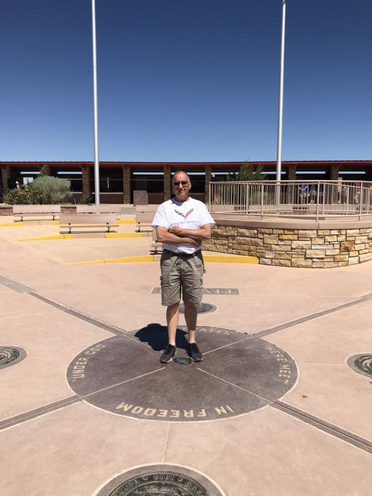
Our second stop of the day and the final stop in New Mexico was Four Corners Monument. Four Corners is the place where you can stand in four states at one time: New Mexico, Arizona, Colorado, and Utah. We lost cell service about 10 minutes before arriving at Four Corners and thought it would pick back up once we got back to civilization but the reality was that we did not regain cell service until we stopped in Flagstaff, Arizona (lovely!!!!) for lunch 24 hours later. The northern parts of New Mexico and Arizona are a dead zone for all mobile carriers – beware!
There were about 20 people at Four Corners when we arrived. There are signs posted requesting people to be respectful of others and asked that each person take a maximum of three pictures. The Skydeck at Willis Tower could take a lesson out of the Four Corners rule book!
Note: It was very windy at Four Corners and I just want to state that I am not growing a lopsided baby or tumor out of the right side of my abdomen as indicated in the photo below.

After my dad took three pictures of me, we switched spots and I took three pictures of him. Never once did I realize he was only standing in three of the four states. Oops.
Next up, nothing about Route 66 and everything about the natural beauty of Page, Arizona.

I want to see Blue Hole!